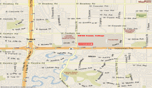
Mesa (Mesa)
 |
 |
Mesa is the third-largest city in Arizona after Phoenix and Tucson, the 37th-largest city in the US, and the largest city that is not a county seat. The city is home to 504,258 people as of 2020 according to the Census Bureau and has been described as "America's most conservative city".
More than 40,000 students are enrolled in more than 10 colleges and universities located in Mesa, including the Polytechnic campus of Arizona State University, Benedictine University, A.T. Still University, Upper Iowa University, Mesa Community College and Chandler-Gilbert Community College. Private for-profit institutions include Arizona College, Carrington College, DeVry University, Pima Medical Institute, and CAE Phoenix Aviation Academy. In January 2020, Arizona State University broke ground on ASU at Mesa City Center, a project offering programs from the Herberger Institute for Design and Arts that will be located in downtown Mesa that is scheduled to open in spring 2022. It is also home to the largest relief airport in the Phoenix area, Phoenix-Mesa Gateway Airport, which is in the southeastern corner of the city.
The history of Mesa dates back at least 2,000 years to the arrival of the Hohokam people. The Hohokam, whose name means "All Used Up" or "The Departed Ones", built the original canal system. The canals were the largest and most sophisticated in the prehistoric New World. Some were up to 90 ft wide and 10 ft deep at their head gates, extending for as far as 16 mi across the desert. By A.D. 1100 water could be delivered to an area over 110000 acre, transforming the Sonoran Desert into an agricultural oasis. By A.D. 1450, the Hohokam had constructed hundreds of miles of canals many of which are still in use today.
After the disappearance of the Hohokam and before the arrival of the early settlers little is known, as explorers did not venture into this area. By the late 19th century near present-day Mesa, U.S. Army troops relocated the Apache, opening the way for settlement.
Mormon pioneer Daniel Webster Jones, with Henry Clay Rogers as his right-hand man, left St. George, Utah in March 1877. Jones had been asked by Mormon officials to direct a party of people in establishing a settlement in Arizona. They traveled south and settled on the north side of the present Mesa area. This settlement was initially known as Fort Utah and later as Jonesville. It was located about where Lehi Road is now. In 1883 it was named Lehi at the suggestion of Brigham Young, Jr.
About this same time, another group dubbed the First Mesa Company arrived from Utah and Idaho. Their leaders were named Francis Martin Pomeroy, Charles Crismon, George Warren Sirrine and Charles I. Robson. Rather than accepting an invitation to settle at Jones' Lehi settlement, they moved up onto the mesa that serves as the city's namesake. They dug irrigation canals and used some of the original Hohokam canals. By April 1878, water was flowing through them. The Second Mesa Company arrived in 1879 and settled to the west of the First Mesa Company because of more available farmland. This settlement was originally called Alma and later Stringtown. It was located about where Alma School Road is now.
On July 17, 1878, Mesa City was registered as a 1 sqmi townsite. The first school was built in 1879. In 1883, Mesa City was incorporated with a population of 300 people. Dr. A. J. Chandler, who would later go on to found the city of Chandler, worked on widening the Mesa Canal in 1895 to allow for enough flow to build a power plant. In 1917, the city of Mesa purchased this utility company. The revenues from the company provided enough for capital expenditures until the 1960s. During the Great Depression, WPA funds provided paved streets, a new hospital, a new town hall and a library.
After the founding of the city the elected official that most impacted the municipality was George Nicholas Goodman. He was mayor 5 different times in parts of 3 different decade (1938–1942, 1946–1948, 1952–1956) (see: List of mayors of Mesa, Arizona). As mayor he was directly involved in the process of acquiring land for both Falcon Field and Williams Field.
With the opening of Falcon Field and Williams Field in the early 1940s, more military personnel began to move into the Mesa area. With the advent of air conditioning and the rise of tourism, population growth exploded in Mesa as well as the rest of the Phoenix area. Industry—especially early aerospace companies—grew in the 1950s and 1960s. As late as 1960, half of the residents of Mesa made a living with agriculture, but this has declined substantially as Mesa's suburban growth continued on track with the rest of the Phoenix metro area.
Map - Mesa (Mesa)
Map


Country - United_States
 |
 |
| Flag of the United States | |
Indigenous peoples have inhabited the Americas for thousands of years. Beginning in 1607, British colonization led to the establishment of the Thirteen Colonies in what is now the Eastern United States. They quarreled with the British Crown over taxation and political representation, leading to the American Revolution and proceeding Revolutionary War. The United States declared independence on July 4, 1776, becoming the first nation-state founded on Enlightenment principles of unalienable natural rights, consent of the governed, and liberal democracy. The country began expanding across North America, spanning the continent by 1848. Sectional division surrounding slavery in the Southern United States led to the secession of the Confederate States of America, which fought the remaining states of the Union during the American Civil War (1861–1865). With the Union's victory and preservation, slavery was abolished nationally by the Thirteenth Amendment.
Currency / Language
| ISO | Currency | Symbol | Significant figures |
|---|---|---|---|
| USD | United States dollar | $ | 2 |
| ISO | Language |
|---|---|
| EN | English language |
| FR | French language |
| ES | Spanish language |